A Coastal Walk Planned Around the Turn of the Tide
Plan a coastal walk around the turn of the tide with local safety advice, a clear exit route and a flexible alternative if conditions change.
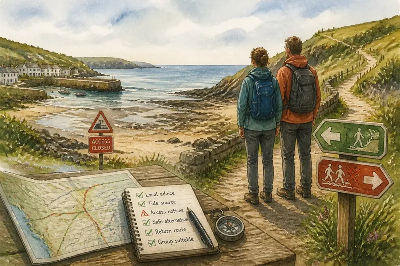
A coastal walk planned around the turn of the tide should be built around local safety advice, not a tide table alone. Before choosing a route, confirm that the shore is suitable for walking, learn how access changes there, and identify a safe alternative that avoids the water’s edge.
Which kind of coastal route suits the walk?
Choose a stretch where the tide changes what you can see, without assuming that a beach passage or causeway is safe to cross. A signed path above the shore may offer a straightforward walk; a low-lying route can involve hazards that require specific local knowledge.
Check current local notices and ask the relevant harbor office, visitor center, coastguard service, or local authority about access concerns. If a route includes an exposed crossing, fast-rising water, cliffs, mud, or slippery rock, do not treat a general route-planning framework as sufficient. Follow official guidance, and choose a different walk if the route’s safety is unclear.
Say you want to walk from a village harbor to a broad beach, then return on a marked path above the coast. First, check local notices and ask the appropriate local authority whether the beach section is suitable and open. If they advise against it, take the higher path in both directions; the result is a walk that avoids the uncertain crossing while still offering coastal views.
How do you check tide information safely?
Use the tide source recommended for the exact stretch of coast, and confirm that its predictions apply to your planned location. A nearby station may not describe conditions at a particular inlet or passage. Ask a local authority which source to consult, and check current notices on the day of the walk.
Note the expected direction of the water’s movement as well as the predicted turning point. Neither a tide table nor a prediction establishes that a specific route is safe: wind, swell, rain, shoreline shape, and local restrictions can affect conditions. If the route depends on a crossing or changing access, rely on site-specific official advice. Do not attempt it if you cannot confirm that it is appropriate for your group and conditions.
How can you plan a route with a safe alternative?
Mark the start, the section affected by the tide, and an inland or elevated route that avoids that section. Check that the alternative is open, publicly accessible, and suitable for everyone in your party; a line on a map is not enough to establish any of those things.
Keep the access-dependent section short and avoid adding distant stops that could put pressure on the timing. Agree in advance that you will use the alternative if local advice, signs, or conditions raise a concern. Never bypass a barrier or improvise a crossing to preserve the original route.
For example, imagine a couple plans to walk from a harbor to a beach and return by a higher trail. They check the local authority’s notice before leaving and find that access to the beach is closed. They follow the checked higher trail instead, so the outing remains a coastal walk without entering the restricted area.
What should you check before setting out?
- Local tide source: If the local authority recommends a source that applies to your route, use it alongside current notices; if you cannot establish which source is relevant, choose a route that does not depend on tidal access.
- Access notices: If an official notice closes or restricts a path, follow the restriction and take a checked alternative; if no suitable alternative is open, choose another walk.
- Route hazards: If the walk includes a crossing, mud, slippery rock, or another feature you cannot assess confidently, ask the relevant local authority or a qualified local guide; if advice remains unclear, avoid that section.
- Return route: If an open, accessible higher route provides a way back without the exposed section, keep it as your alternative; if you cannot verify a safe return, select a different route.
- Group suitability: If the route matches everyone’s mobility, footwear, and experience, proceed only within current local guidance; if it does not, use a more suitable path.
- Offline navigation: If you have a paper map or an offline map saved, keep it available for the route; if you do not, prepare one before leaving or choose a simpler, clearly signed walk.
- Changing conditions: If weather, water, or local advice makes the shore uncertain, leave the exposed area and follow your alternative; if no safe alternative is available, end the walk and seek local assistance as appropriate.
What do walkers ask about a tide-led coastal route?
Which tide station should I use?
Ask the local authority or harbor office which source applies to your specific stretch of coast. If you cannot confirm that a prediction is relevant to the route, do not use it to decide whether a crossing is safe.
Is a tide table enough to judge a beach crossing?
No. A tide table is a planning aid, not a site-specific safety assessment. Follow current local advice and avoid a crossing if its safety is uncertain.
What should I do if the beach route is closed?
Respect the closure and use an alternative only if it is open, accessible, and suitable for your group. If no appropriate option is available, choose another walk rather than trying to get around a barrier.
Should I walk on a rising or falling tide?
There is no general answer that makes a particular route safe. Follow local, site-specific guidance, and choose a route that does not require you to judge a hazardous crossing on your own.
How can the tide shape what you notice?
Choose a safe place away from changing water and keep the return route in view while you pause. Notice how the shoreline looks from a signed path or another location approved for visitors: sand, rocks, stream mouths, and boats can all look different as the water changes.
The search phrase “coastal walk planned around the turn of the tide” describes a way to frame the day, not permission to rely on a prediction for a safety decision. Save the local authority’s guidance and your checked alternative route together before leaving. If conditions or advice change, take the safer option and enjoy the coast from there.